Bear Valley and Point Reyes Station
Use the visitor-center area to check the day’s plan. Arrange fuel and food before heading farther west; verify opening hours rather than counting on a late return.
Make the coast the destination and leave room for the drive. This route follows Sir Francis Drake Boulevard toward the lighthouse parking area, with a walk beyond the car park if access and weather permit.
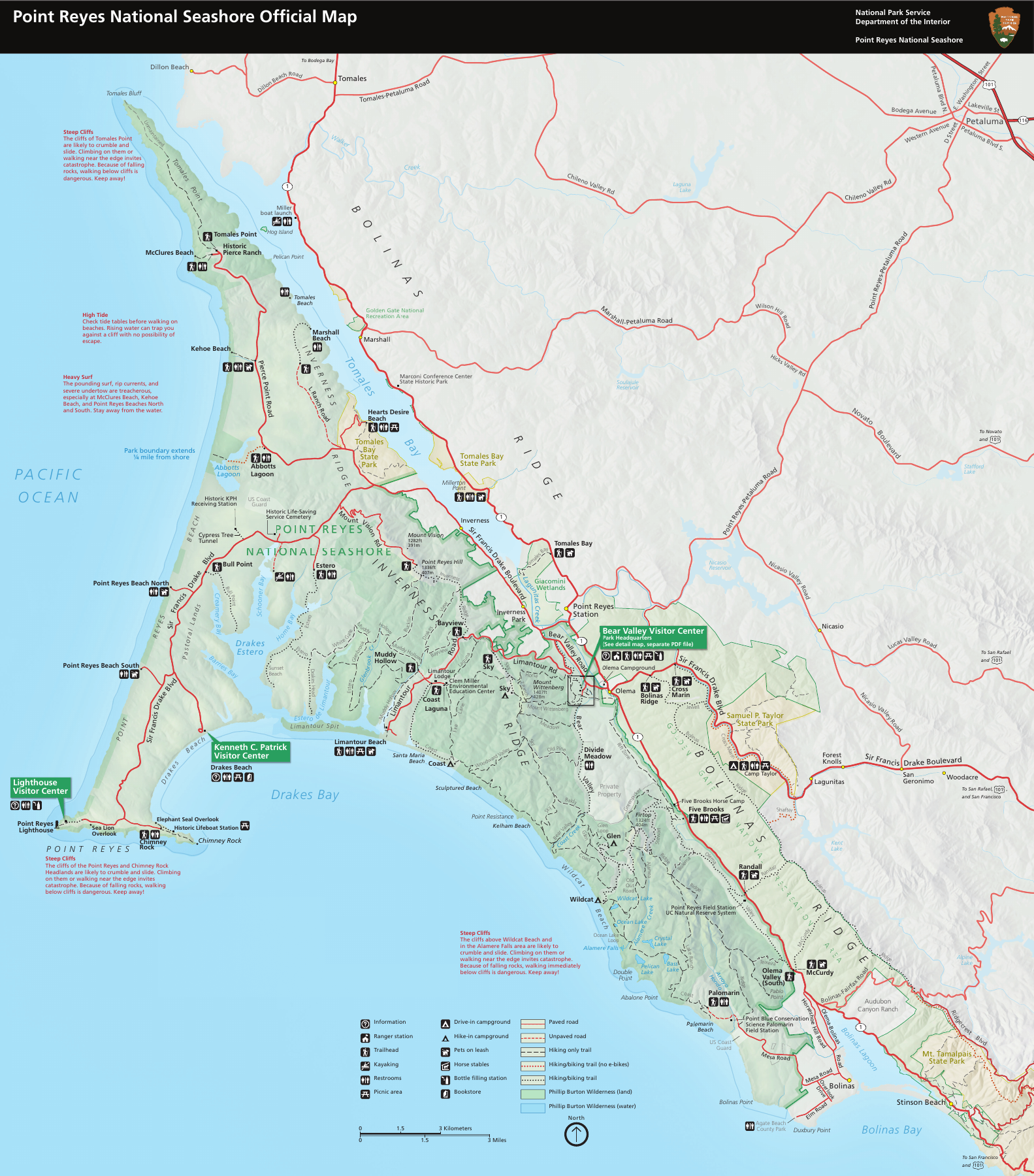
From the Bear Valley area, use the park’s signed directions to Sir Francis Drake Boulevard and follow it west through Inverness toward the Point Reyes headlands. Continue to the lighthouse visitors’ parking lot. Return along the same road; do not assume a coastal through-road exists beyond the lighthouse.
Budget a half day if you want an unhurried drive and a lighthouse-area visit. NPS lists the nearest fuel in Point Reyes Station, limited food options farther west and very limited phone reception near the lighthouse. Carry the directions and map before losing service. For photographs, use designated visitor areas and leave the road clear.
Use the visitor-center area to check the day’s plan. Arrange fuel and food before heading farther west; verify opening hours rather than counting on a late return.
Continue along Sir Francis Drake Boulevard. Keep any stop to designated public parking and stay clear of ranch entrances and private land.
Use the provided restrooms and decide whether the walk suits the conditions and everyone in your group. The lighthouse itself is not a roadside stop; check stair access separately.
Check NPS alerts and the coastal forecast before leaving. A park brochure map does not establish that a road or facility is open today. Fog can hide scenery and reduce visibility; strong wind can affect the walk and lighthouse access. Obey posted limits, give cyclists and wildlife room, and stop only where parking is permitted.
Choose it when you want one coastal destination rather than a day of collecting stops. The return along the same road makes the decision simple: allow enough time for the far end, then keep spare time for weather, traffic and people moving at a different pace. The route is a poor fit for a rushed sunset arrival or a drive built around speed.
Use the Bay Area scenic-drive guide to compare other coastal and inland options. Check their individual access information; this route’s distance and time do not apply to a combined loop.
A researched planning guide based on National Park Service information. It is not a first-hand road test. Conditions, access and opening hours can change; check the linked official alerts before departure.