Follow the north end of the Point Reyes peninsula to historic Pierce Ranch and the Tomales Point trailhead. Choose a short ranch visit or a separately planned walk, and leave time for the same-road return. This guide is researched from National Park Service sources; it is not a first-hand road test.
Start
Bear Valley Visitor Center, Point Reyes National Seashore
Finish
Pierce Ranch / Tomales Point trailhead parking lot
Distance
About 16.6 miles one way; 33.2 miles return on the same roads, excluding side trips
Driving time
NPS allowance: 35 minutes each way; 70 minutes return, before stops
Road character
Scenic and winding; slow-going coastal and rural roads
Suggested visit
Daylight with an early arrival; allow a half day including a short visit and approach travel
Season
Late September to early November can bring clearer coastal days; check the forecast in every season
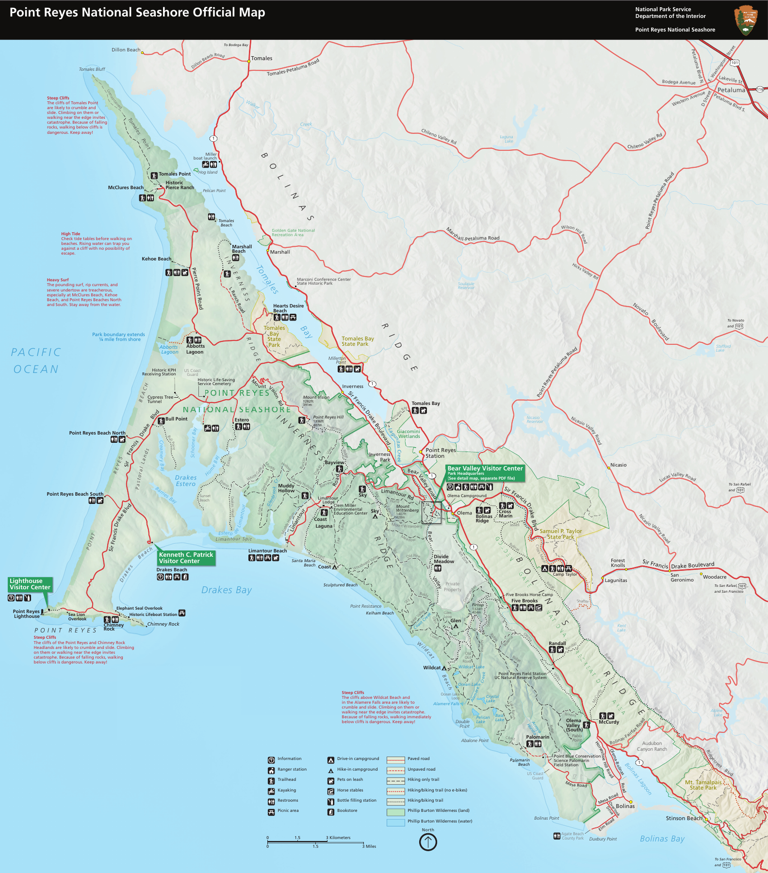
National Park Service park map. Follow the written route below; this map does not show live closures. Map source: NPS. Official map and closure updates
The written route
From Bear Valley Visitor Center, drive northwest about 2 miles on Bear Valley Road. Turn left onto Sir Francis Drake Boulevard and continue 5.6 miles. At the Y signed for Tomales Bay State Park and Pierce Point Ranch, take the right fork onto Pierce Point Road. Follow it about 9 miles to the Pierce Ranch / Tomales Point trailhead parking lot. Return on the same roads. The left turn to McClures Beach just before the ranch lot is an optional 0.2-mile spur, not part of the 16.6-mile main route.
Stops, facilities and time
Our suggested half-day plan combines the NPS 70-minute return driving allowance with one to two hours for a short visit, plus your travel to Bear Valley and a margin for traffic and weather. That is an editorial itinerary, not a measured journey time. The full Tomales Point trail is a separate 9.7-mile round-trip hike; it does not fit this short-visit plan. Decide on the walk, turnaround time and return reserve before parking. Phone reception may be minimal or absent.
Bear Valley: start with water and the day’s conditions
Fill drinking water before leaving; NPS lists no potable water at Tomales Point. Check alerts and download or print the park map and directions. This is the route’s start, so travel here from your home is additional.
Point Reyes Station and Inverness: arrange food and fuel
Plan these errands before committing to the peninsula. NPS lists the nearest fuel in Point Reyes Station, about 16 miles from Tomales Point, and no food west of Inverness. Confirm business hours and bring what you need. No charging stop is verified by this guide; EV drivers should confirm a working charger and sufficient return range in advance.
Pierce Ranch: the main destination
The dirt trailhead lot holds about 20 vehicles and may fill by 10 a.m. on busy weekends and holidays. A self-guided ranch visit gives this drive a destination without committing to the full Tomales Point hike. Use designated visitor areas for photographs and keep entrances clear.
McClures Beach parking: optional facilities stop
The separate spur descends about 0.2 mile from the ranch approach. NPS lists a paved lot of about 25 spaces and a vault toilet. Confirm access on the day; this spur adds distance beyond the main route. Reaching the beach involves a separate steep walk and serious surf hazards, so a restroom stop need not become a beach outing.
Before you drive
Read the current NPS alerts and coastal forecast before departure. The map and this source-check date do not establish that the road or a facility is open today. Slow for bends, fog, cyclists and wildlife, obey posted limits and use legal parking. Soft roadside shoulders can trap vehicles in winter and spring; do not treat a full lot as a reason to park on unstable ground. Stay on designated paths, keep clear of cliff edges and do not approach or feed wildlife.
Choose the drive that fits your day
Choose this route for a defined out-and-back outing, a historic ranch stop and coastal walking options. Skip the long trail when the aim is an unhurried drive with a short visit. A dawn-to-dusk road collection or a rushed sunset arrival leaves little margin for a full parking lot or a slow return.
For a low car, the dirt destination lot and soft shoulders deserve a separate decision. This guide has not measured surface clearance or verified pavement condition. Inspect access when you arrive, stay within permitted parking and turn back if it is unsuitable; no specific sports car is guaranteed to fit.
Time of day and season
Aim for an early daylight arrival to improve the chance of parking; it does not guarantee a space. NPS describes clearer coastal weather in late September, October and early November, but autumn storms and strong November–December winds can change that picture. Summer headlands can stay foggy, winter brings the heaviest rain and spring is often windy. Choose the current forecast over the calendar, and carry layers, water and a return plan.
Children, dogs and walking choices
Keep the walking plan separate from the drive. The full Tomales Point hike is 9.7 miles return; a short ranch visit is a different outing. NPS prohibits dogs beyond Pierce Point Road and the parking lots, with an exception for working service dogs. Do not leave a dog unattended in a vehicle. Check the official pet and accessibility information for your group before setting out.
McClures Beach has intense surf and sneaker-wave hazards. Do not assume a coastal stop is safe for swimming or tidepooling. Follow current NPS beach-safety advice, stay away from cliff edges and choose the ranch visit when conditions do not suit a beach walk.
A nearby alternative, not an extra stop by default
Compare the Point Reyes Lighthouse drive if the lighthouse is your main goal. It uses a different branch of the peninsula; its drive time is additional, not included in this itinerary. The Bay Area scenic-drive guide offers inland alternatives when coastal conditions are poor. Check each destination separately.
How this resource was researched
Researched from the National Park Service pages listed below, checked November 3, 2026. No first-hand drive, original route photograph, live road inspection or vehicle-clearance test is claimed. Mileage and driving allowances come from NPS; 33.2 miles is twice its 16.6-mile one-way estimate. The half-day itinerary and decision prompts are our editorial suggestions.